Monday, August 29, 2016

Wanakena

 
The Inlet Flow, looking  toward the Narrows and Cranberry Lake

We spent the past week in Wanakena, enjoying the quiet, solitude, and beauty all around us. Although only six miles from Star Lake, Wanakena differs in several ways.

1- What is now known as Cranberry Lake was once a smaller lake, enlarged by damming of the Oswegatchie River near Cranberry Lake hamlet. The Inlet Flow, shown in the above photo was once a river floodplain. It now consists of the relatively deep former river channel and the shallow inundated floodplain. Its character is not quite lake-like and not quite river-like, but somewhere in-between. Star Lake is a glacial lake that has probably been shrinking over the past 10,000 years.

2- Star Lake has clear water, and a sandy bottom. Cranberry lake in contrast has tea-colored water, produced by seepage laden with humic acids leached from fallen leaves and decomposing wood into the Oswegatchie . Note the color of the water in the image below. The bottom may be sand, gravel, or silt.

Bathing at the Wanakena beach
3- Star Lake and most of the surrounding area is situated on a thick, relatively flat bed of sand, gravel, and small rocks that are the remnants of a glacial outwash plain. These materials were carried by water rushing out of a melting glacier. Wanakena, in contrast, is built on a glacial moraine. Its rough topography is littered by large rocks, some as big as houses, that were dropped in place by a melting glacier. Note the rocks on Third Street in the image below. The vegetation differs as a result of these differences in geology. Red spruce, for example, is a dominant in the Wanakena area, but relatively rare in Star Lake.
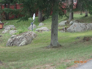
Rocks dropped by a melting glacier
4- Wanakena at about 64 people has only about one tenth of the year-round population of Star Lake, but has its own water and sewer systems. Star Lake is served in part by a public water supply, but no public sewers. Neither hamlet has a formal local government, and both are governed as parts of the Town of Fine.

5- In spite of, or in fact because of its small year-round population, Wanakena has a keen sense of community--keener some would say than in Star Lake. Rebuilding of the iconic Wanakena footbridge that was destroyed in an ice jam is one effort that has helped draw the community together.
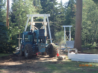
Rebuilding the footbridge
6- The original houses in Wanakena were carried by rail from Pennsylvania, where they had served to house the workforce in a lumbering operation. Reassembled in Wanakena, they resumed their role as supporting workers of the Rich Lumber Company. Some today serve as seasonal residences. Many of the homes in Star Lake were originally built as summer residences, and now serve as full-time dwellings. Only a few were built to serve the workforce at the Benson Mines.

Saturday, August 20, 2016

Clifton-Fine, One Year On


The New Gem of the Adirondacks came out just one year ago, in August, 2015. It explored how far the Clifton-Fine community had come in its efforts to rebuild, following the collapse recorded nearly 10 years earlier in the original Gem of the Adirondacks. Now that this first annual milestone has been reached, it seems appropriate to ask what has become of the many things that were in the works, or were showing promise a year ago.

What is new and better? Two signs of progress are highly visible. The first is the beginning of construction to replace the destroyed Wanakena footbridge. The second is the rebirth of the closed IGA food store as the Star Lake Great American. Though each of these has merely replaced something that was recently lost, and in that sense is a limited kind of progress, each is important in a unique way. 

Replacement of the footbridge required a concerted community effort and, in its successful execution it not only is restoring a lost attraction, but it has also greatly strengthened the ties that hold the community together.
Newly poured concrete abutments that will anchor the footbridge
Arrival of the Star Lake Great American likewise has two benefits. First, it has relieved the community of a hardship in the need to travel unreasonable distances to obtain basic necessities. Beyond that, it offers the prospect that having a vital new business will attract customers from surrounding communities and strengthen the larger role of Star Lake as a regional service center. People may come here to get what they need, rather than leaving the area.
 
Sign welcoming customers to the new grocery
Perhaps the most promising new developments are occurring at the former J&L site. Efforts continue to clean up pollution, and a crushing operation using rocks removed from the mine pit 50 years ago that was in a pilot phase in 2015 has now greatly expanded and is shipping materials to various customers. Rehabilitation of the rail line continues and, when complete, would seem to much improve the economics of the operation. Availability of the rail link will also improve prospects for use of the former paper mill plant in Newton Falls.

 
Crushed stone production from a former J&L waste rock pile


The vibrant Coffee Fever has also become a significant community asset.

Disappointments continue, of course, and most disappointing has been failure of the Town of Clifton board to support merger of  administrations of the two towns in order to achieve greater efficiency, improved quality of services, and reduced property taxes. This setback is particularly troubling for the hamlet of Cranberry Lake, which has long been disappearing and now seems likely to continue its steady decline.

Other changes for better or worse are underway, and they may be addressed in future posts.

In Clifton-Fine Again

Star Lake in a Google Earth image

I finished The New Gem of the Adirondacks over a year ago, and have resolved to think little, if at all, about the Clifton-Fine community. Thinking and worrying about its fate in preparing the book was an occupation that took nearly two years, and this trip was not to be about research but instead was to be a vacation.

Nevertheless, things happen and things change, and it is difficult not to think about what is happening in a community seeking to  revitalize itself and redeem much that was lost in the past. I'm not about to write another book, but I may from time to time put up a blog post recording the changes of the past year for better or worse. One article on the web did attract my attention today, and I'm including a link here. It may, or may not, be relevant for Clifton-Fine, but it does provide some food for thought. The link is here.

Monday, February 22, 2016

The New Tram Ridge Trail at the Lower Suwannee National Wildlife Refuge

Staff of the Lower Suwannee National Wildlife Refuge have recently completed a new trail in the refuge headquarters area near Fowler's Bluff, Florida. It is an unusually appealing trail, and anyone completing the 2.8 mile loop can get a better understanding of the past, present, and desired future of the refuge.

Forking to the right at the beginning of the loop and going in a counterclockwise direction, visitors first pass through an area with widely spaced pine trees and extensive low vegetation.

Former Pine Plantation Undergoing Restoration
Once a tree farm densely planted with slash pines (Pinus elliotii), restoration efforts have included removal of many of the pines, opening the canopy and permitting light penetration to the ground to promote the growth of a diverse community of low-growing plants. Regular controlled burns prevent the invasion of hardwood trees. The natural vegetation of the area would have included widely-spaced longleaf pines (Pinus palustris), and management here has sought to functionally recreate this landscape--a savanna--that historically covered much of Florida and the southeastern coastal plain. Longleaf pines are being reestablished in parts of the refuge, but this restoration strategy is costly, laborious, and mostly undertaken on relatively small sites. Large scale thinning planted stands of slash pines is feasible and believed to be an efficient substitute.

Interspersed with the pine savanna are occasional wetlands dominated by pond cypress (Taxodium ascendens) and mesic hardwoods such as red maple (Acer rubrum).

Wetland
Slash pines like moist soil, but another species, loblolly pine (Pinus taeda) occurs on even wetter sites normally on the edges of wetlands.

Loblolly pine on the edge of a wetland.
Loblolly pines are relatively rare on the refuge. They can be distinguished from slash pines by shorter needles, smaller cones, darker bark with reddish, rather than brownish plates, and upward branching rather than dome-like crowns.

Even rarer are longleaf pines. Those in the photo below were found in a small patch where the trail comes close to County Road 347. Very long needles, large cones, bark that is scaly rather than broken into regular plates, and more open crowns distinguish these pines from the others. I saw no sign of reproduction of longleaf here, although these trees may not yet be old enough to produce fertile cones.


Longleaf pine.
Growth of pine trees is not the ultimate goal of habitat restoration. That goal instead is to promote the growth of the rich understory that is the repository of much of the region's biological diversity. Low woody vegetation, includes saw palmetto (Serenoa repens), gallberry (Ilex spp.), fetterbush and staggerbush (Lyonia spp), and other hardwood shrubs. These do not normally completely cover the ground, and are kept in check by fires. Resultant openings leave room for diverse grasses and forbs, and provide favored habitat for species like the gopher tortoise (Gopherus polyphemus) and the constellation of species that its presence promotes.

The trail crosses a small hardwood hammock and soon enters an area of scrub forest.

Scrub
This dry area is shaded by a thin canopy of scrub oaks, prominently
including sand live oak (Quercus geminata) and myrtle oak (Quercus myrifolia). This area is probably too dry for growth of pines, and its trees have little or no economic value. Loggers did put the ridge to use, however. It proved to be an ideal place to build a tram trail--a light railway used for getting lumber on its way to markets. As can be seen in the photo below, very little effort was needed to build a roadbed here.

Tram trail

A flat, straight trail could be constructed with little need to move significant quantities of earth. Unfortunately, the ridge gave out before its builders had achieved the desired distance, and as the landscape became wetter, it became necessary to construct a more substantial embankment.


Embankment

Not only did continuation of the tramway require more work, but it caused more serious and longer lasting damage to the environment. Acting like a dam, the half mile long embankment interrupted the normal flow of surface and ground water, making some places wetter, and others drier than before. In places ponds were formed where they would not otherwise have occurred.


Pond vegetation in a ditch created by construction of the tramway embankment

Changes caused by construction of logging roads are a problem throughout the refuge, and they are unlikely to be reversed, owing to the level of effort required and the difficulty of recreating drainage patterns that were disrupted long ago. The problem of hydrological change is particularly severe in the refuge's lowland swamps where ditches interrupt sheet flow of water. Some uplands have been further damaged by "windrowing," in which deep furrows were dug in order to create artificial "slashes" --depressions that would collect moisture and favor the growth of slash pines. 

Despite various habitat alterations, the Lower Suwannee National Wildlife Refuge is a rich repository of biological diversity. In the first mile of the Tram Ridge Trail one encounters a restored pine savanna, and large and small patches of different communities, including forested wetlands, palmettos and hardwood shrubs, grasslands, a hardwood hammock, and xeric scrub. Each of these habitats has its own assemblage of plant and animal species, and the mosaic they form accommodates a diverse mixture of species favoring not only each different habitat, but also those favoring their borders and the transition areas between them. 

By the end of the trail visitors will have gotten a better understanding of damages done to the natural environment by industrial timber production. These include more or less reversible damage being addressed by ongoing restoration activities, and the less reversible changes resulting for road construction and other landscape alterations. The restored pine plantations provide a glimpse of what the natural savanna vegetation of the region might have looked like. They also provide hope for the future in the eventual restoration of their diverse plant and animal communities.